 The BERG 100 - Out and return(50 km straight line) click on the picture to make it bigger
The BERG 100 - Out and return(55km by road) click on the picture to make it bigger
Well the long weekend has come and gone and having four days away from work gives one the option to go somewhere one can not do on a normal weekend.
Some of our BERG member had opted to go down to Volksrust for a slope weekend (Charl and Peter) while others like "If you can’t go Big, Stay Home", Mike and Chris, had opted to stay home and build while Evan and myself let the adventure bug lose and went down to the Free State to map out the upcoming BERG 100 monster cross country route.
Charl has promised me a report and pictures on the Volksrust outing, and Mike was very secretive about his latest project and I don’t think he will let "Wit Willem De Kat" out of the bag
at this stage.
I set my cell phone alarm to wake me up at 5 am on Saturday morning as we planed to leave
Evan’s place at round 6. We managed to get away at 6.30 and headed towards Ventersdorp traveling in a westerly direction to our destination as our over night place was at Hugh Edmunds home in Wolmaransstad +/- 250km away. We went on a slightly longer route as we wanted to see if there was a possible, closer cross country route, to the PWV area. With me driving and Evan taking notes, it felt more like a motorcar rally, with odometer readings, landmarks, landing fields, trees, dams and cross roads being noted and jotted down on Evan’s notepad. We stopped at Klerksdorp for breakfast and then set of on the last 80 km stretch to Wolmarnsstad and Hugh’s home and arrived there at around 11.00 am.
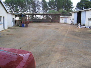
After we had good chat and a nice cup of coffee we set out to drive the course with Hugh joining us now and sharing his local knowledge of the area. The main idea was to find a route that was quiet in terms of traffic, straight and long (100 km) with good open landing place on the both side of the road. Both Evan and myself had had a good look on Google Earth and identified the route that we now were riding on. The first part of the journey, Wolmaransstad up to the Vaal river was promising but not ideal. However when we crossed the Vaal river, the road became, wide, straight and level. At this stage we also identified a farm house and an adjacent starting/launching field.
 Launch field
From here the stretch lasted for +/- 40 km before we came to the only kink in the route near the little town of Wesselsbron were we ran into T junction. Here we had to turn right and after a further +/- 3 km a stop street. A left turn here and now we were on long slightly downhill run of 30 km to the T junction to Odendaalsrus and Welkom. Once again the road became wide with lots of landing space on both sides and straight as can be.


See the Google earth image’s so you can get the idea of what the course will look like.
So the total distance that one can fly in one direction is +/- 70 Km. I propose to have a turn point at 50km (straight line and then you have to return to base giving a total of 100 Km) The distance by road is 55 km one way and a total of 110km in total. Hugh at the end of the BERG 100 course near Welkom (70 km)
At the end of this stretch (Odendaasust) we turned right to Welkom to pop in for quick visit and lunch kindly supplied by Ricky and his wife. The time was now close on 3PM and we had to tackle the return journey. As we got to the planed staring point we turned in at the farm house that we saw earlier on. The farm belong to Oom Willie Jacobs and after knocking on his door with no reply we eventually found him at the back at his barn. We helped him to carry his groceries in and he offered us some coffee. He agreed that we can use the field across the road from his farm house as a launch field and his farm for secure parking of car’s when we do go there to fly the BERG 100.
Secure Parking

Oom Willie Jacobs, Hugh and Evan having a chat on the BERG 100.
After a pose for pictures we returned to Hugh’s home were we had a fantastic braai with the best potato salad ever. When hit the sack later on and Evan and myself were so tired that we fell asleep instantly. I tried to snored him awake all night long but he wouldn't budge.
On Sunday morning, after a breakfasts at the Wimpy we returned to Evan's place and then to the BERG field to for some Sunday afternoon flying.
All the information that we obtained will now be worked on and submitted to SAMAA for approval of the BERG 100. We hope to fly it on the last weekend of July 2007 and the pilot that can finish this monster out and return BERG 100 Cross Country will win himself a well deserved R1000.00. (R10.00 per km)
Rules and other related information will follow shortly. So watch this Blog.
To Ricky and Hugh. Thanks for the fantastic hospitality and we are looking forward making the BERG 100 a great cross country event.
 Visiting Ricky in Welkom, Evan admiring the workshop. (Home of the famous Mitchell winch)
 Having fun In Hugh's workshop (What is that a power arie doing in a glider workshop?)
 Old friends meeting again.
1 comment:
I am in, set a time and date ,looks like a good challange in the right type of countryside.
regards
Mike M
Post a Comment